
How does aerial real estate photography improve marketing for large properties?
Ever feel like your listing photos just can't capture the true scale of a sprawling estate or a massive commercial lot? When you’re dealing with significant acreage or high-end builds, standard ground-level shots often fail to tell the whole story, leaving potential buyers guessing about the layout and the surrounding landscape.
Traditional photography can feel flat and disconnected, especially for expansive properties where the relationship between the main structure and the land is the biggest selling point. Without that "big picture" perspective, you risk losing the interest of serious investors and luxury buyers who need to see the full scope before they commit to a tour.
In this guide, we’ll show you how aerial real estate photography transforms your marketing strategy, turning complex listings into immersive visual experiences that command attention. Whether you are looking for high-end drone shots for real estate or cinematic drone videos for real estate, we have the insights to help you stand out.
Let’s dive into why taking your marketing to the skies is a game-changer for your portfolio.
Elevating Your Perspective with Aerial Photography for Real Estate
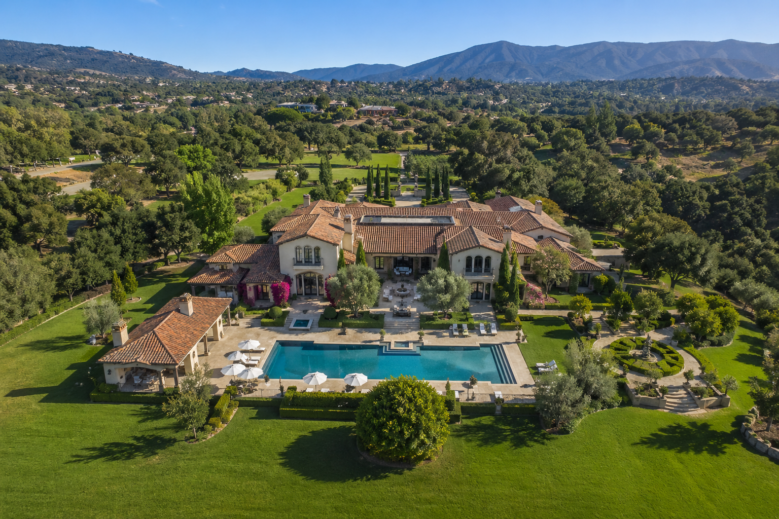
Aerial real estate photography is the process of capturing high-resolution images and cinematic video of a property from an elevated vantage point, typically using advanced drone technology. Unlike traditional photography that views a home from the curb, real estate aerial photography provides a comprehensive "bird’s-eye" view, offering a sense of scale, depth, and context that is impossible to achieve from the ground.
For large estates, expansive land, and luxury developments, this perspective isn’t just a "nice-to-have"—it is a fundamental marketing requirement. When a property spans several acres or features complex structural layouts, ground-level photos can be misleadingly narrow. High-quality drone photos for real estate bridge that gap, allowing potential buyers to see exactly how a home sits on its lot and its proximity to local landmarks or natural features.
By utilizing professional drone services for real estate, you provide a level of transparency and professionalism that builds immediate trust with high-intent buyers. This approach offers several key advantages:
- Defines Property Boundaries: Clearly shows the extent of the land and lot lines.
- Highlights the Neighborhood: Showcases surrounding amenities, views, and privacy.
- Captures Massive Scale: Easily documents large commercial properties and land and lots in a single frame.
- Enhances Visual Engagement: Provides a "wow factor" that stops the scroll on listing sites.
While some believe that luxury drone photography is reserved only for multi-million dollar mansions, the truth is that any property with unique outdoor features or significant acreage can benefit from this vantage point. Understanding these foundational benefits is the first step in creating a listing that doesn't just show a house, but sells a lifestyle.
Why Aerial Real Estate Photography is the Secret Weapon for Large Property Marketing
Marketing a large property presents a unique set of challenges. When you have dozens of acres, a massive industrial complex, or a multi-structured estate, ground-level photos simply cannot convey the value proposition effectively. This is where aerial photography for real estate steps in. By capturing the property from above, you provide a narrative that ground shots can’t replicate.
Here is how drone services for real estate specifically solve the problems of marketing large-scale listings.
1. Showcasing the Entire Scope and Layout
Large properties are often defined by their boundaries and the relationship between different structures. A standard camera lens can only capture a fraction of a 20-acre lot at once, leaving the buyer to "piece together" the layout in their mind.
Drone shots for real estate provide an immediate, literal "big picture." They allow a buyer to see the distance from the main house to the guest cottage, the path of the driveway, and the exact location of outbuildings or water features. This clarity reduces "buyer's fatigue" from looking at dozens of disjointed ground photos and replaces it with a single, comprehensive understanding of the estate's footprint.
2. Highlighting the Surrounding Context and Amenities
For luxury buyers, the property doesn't end at the fence line—it’s about the lifestyle and the location. Is the property near a prestigious golf course? Does it have private beach access or a view of the mountains?
Using real estate aerial photography, you can zoom out to show the property’s proximity to local landmarks, schools, and natural beauty. This is particularly vital for residential properties and rental properties, where the neighborhood is just as important as the floor plan. Seeing a house nestled in a lush valley or a commercial building right off a major highway exit provides instant "spatial proof" of its value.
3. Creating Emotional Impact with Drone Videos
Static images are powerful, but drone videos for real estate offer an immersive experience that triggers an emotional response. A cinematic "fly-over" can mimic the feeling of arriving at a grand estate, moving from the entrance gate, up the long driveway, and circling the main residence.
Drone filming for real estate marketing allows you to tell a story. By incorporating smooth, sweeping motions, you create a sense of prestige and exclusivity. When paired with video portfolio techniques, these videos keep potential buyers on your listing page longer, increasing the likelihood of an inquiry.
4. Demonstrating Utility for Land and Commercial Use
For developers and investors, drone footage real estate serves a practical, technical purpose. If you are selling a land and lot listing, drone imagery can highlight topography, soil types, and clearing potential.
In the world of commercial properties, aerial views are essential for showing roof conditions, parking capacity, and traffic flow access. It provides the "due diligence" visual data that serious investors look for before they even pick up the phone.
5. Standing Out in a Competitive Market
The real estate market is increasingly visual. Listings that include drone photography for realtors receive significantly more clicks than those without. In a sea of standard gallery photos, a high-quality aerial thumbnail stands out. It signals to the buyer that this is a high-value listing handled by a professional who cares about detail.
To further elevate the look, many agents combine aerial views with specialized lighting techniques like real twilight or virtual twilight. Seeing a large estate glowing at dusk from a 100-foot elevation is a powerful marketing image that defines luxury drone photography.
Pro Tip: When scheduling your drone shots for real estate, aim for "Golden Hour"—the hour after sunrise or before sunset. The long shadows and warm light add depth to the terrain and make large landscapes look truly magical.
Real-World Applications of Aerial Photography for Real Estate
Understanding the benefits is one thing, but seeing how aerial real estate photography performs across different property types demonstrates its true versatility. From luxury homes to massive industrial sites, the right perspective changes everything.
- Luxury Residential Estates: A realtor representing a five-acre residential property with a pool, tennis court, and guest house used drone shots for real estate to create a cohesive tour. By showing the entire lifestyle package in one frame, the listing saw a 40% increase in engagement compared to previous ground-only listings, eventually selling to an out-of-state buyer who felt they "already knew" the layout.
- Commercial and Industrial Hubs: An investment firm marketing commercial properties used drone filming for real estate marketing to highlight the proximity to major shipping ports and highway interchanges. This visual data provided immediate "spatial proof" to stakeholders, cutting down the inquiry-to-tour time significantly by answering logistical questions upfront.
- Acreage and Development Lots: Developers selling land and lot parcels use real estate aerial photography to overlay property lines on high-resolution images. This helps buyers visualize potential building sites and road access, turning a blank field into a clear investment opportunity.
These examples prove that drone photography for realtors is not just about aesthetics; it’s a functional tool that provides the clarity and confidence buyers need to move forward.
Pro Tips for Maximizing Your Aerial Real Estate Photography
Once you decide to integrate aerial photography for real estate into your marketing mix, a few expert refinements can significantly boost the impact of your visual content. High-end imagery is an investment, and these best practices ensure you get the highest return on every flight.
- Coordinate with the Sun: Timing is everything for luxury drone photography. Scheduling your shoot during the "Golden Hour"—the first hour after sunrise or the last hour before sunset—creates long, soft shadows that define the topography of a large lot. This lighting adds a cinematic warmth that makes residential properties feel more inviting and high-end.
- Use Property Line Overlays: For land and lot listings, raw drone shots for real estate can sometimes be confusing. By adding a digital "glow" or line to indicate property boundaries in post-production, you provide immediate clarity. This helps investors quickly understand the usable acreage and road frontage without guessing where the woods end.
- Incorporate Motion for Scale: When utilizing drone videos for real estate, avoid static hovering. A slow, forward-moving "reveal" shot that starts low and rises over the roofline helps viewers internalize the scale of a massive estate. This dynamic movement captures attention much more effectively than a series of still images alone.
- Check Local Flight Regulations: Professional drone services for real estate should always be FAA-compliant. Ensure your pilot is Part 107 certified, especially when filming commercial properties near busy urban centers or airports. This not only ensures high-quality results but also protects you and your clients from legal liability.
By applying these professional touches, you transform standard drone footage real estate into a sophisticated marketing asset that resonates with serious buyers.
Take Your Marketing to New Heights with Brookehaven Media
In the competitive world of high-end listings, aerial real estate photography is no longer just an optional add-on—it is the standard for success. By providing a comprehensive view of a property’s scale, location, and unique features, you give potential buyers the clarity they need to make confident decisions. From cinematic drone videos for real estate to high-resolution boundary shots, these tools transform how you tell a property's story.
We encourage you to start integrating these elevated perspectives into your next listing. Whether you are managing massive commercial properties or luxury residential properties, the right visual strategy will set your brand apart and drive faster closings.
Ready to see the difference professional drone services for real estate can make? Explore our video portfolio to see our work in action, or learn how to further enhance your listing with our real twilight photography services today.
Frequently Asked Questions About Aerial Real Estate Photography
How much does professional aerial real estate photography cost?
The cost of drone services for real estate typically varies based on the property size and the complexity of the shoot. Most professional packages for residential listings range from $200 to $500, while large-scale drone filming for real estate marketing for commercial sites may be higher. Investing in high-quality imagery often pays for itself by attracting higher-tier buyers and reducing the property's time on the market.
Do I need a special license for drone photography for realtors?
Yes, in the United States, any pilot performing aerial photography for real estate for commercial purposes must hold a Remote Pilot Certificate (Part 107) from the FAA. Hiring a certified professional ensures that your project complies with federal safety regulations and airspace restrictions. Using an unlicensed pilot can result in significant fines for both the photographer and the real estate agency.
What is the best time of day for drone shots for real estate?
The "Golden Hour"—the first hour after sunrise or the last hour before sunset—is widely considered the best time for real estate aerial photography. During these windows, the sun is low in the sky, creating soft, warm light and long shadows that highlight the natural contours of the land. This lighting enhances the luxury feel of residential properties and makes landscapes look more vibrant.
Can drone footage real estate help sell vacant land or lots?
Absolutely. For land and lot listings, aerial photography for real estate is often the only way to show the property's potential. Drones can capture the entire perimeter, highlight natural features like ponds or tree lines, and even show the view a future home might have from a second-story window. Adding property line overlays to these images provides the clarity that land buyers demand.