
What are the benefits of aerial property photography for showcasing homes?
Aerial property photography provides a high-impact perspective that traditional ground-level shots simply cannot match. By capturing a home from an elevated vantage point, you instantly reveal the property’s scale, the quality of the roof, and its precise orientation within the neighborhood.
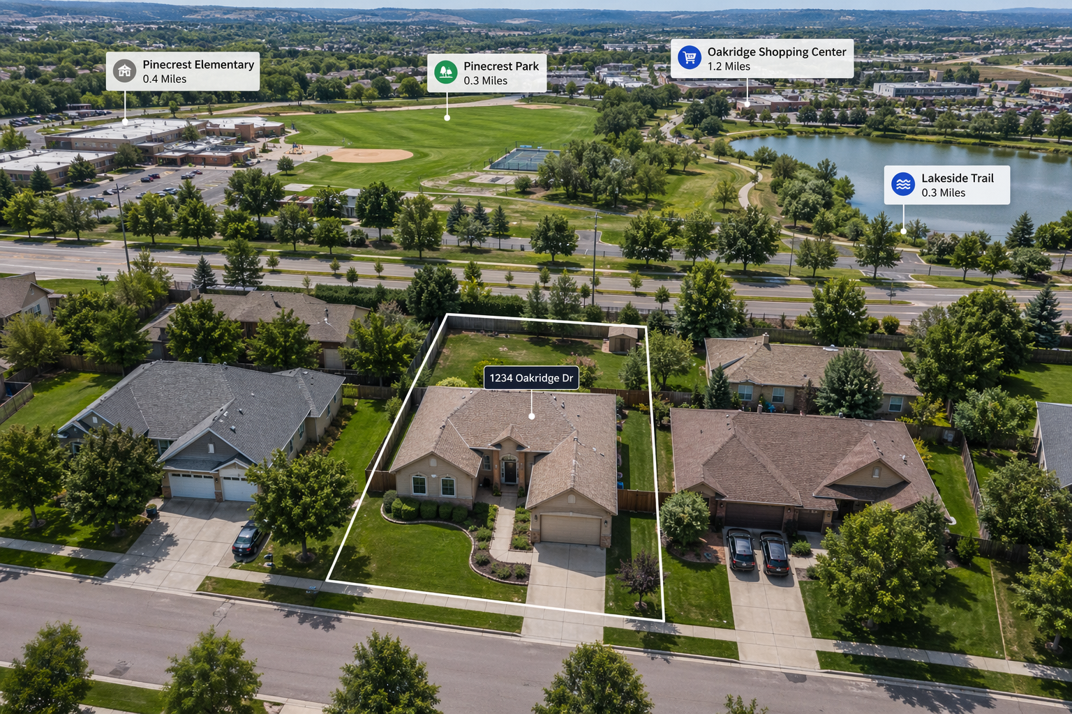
This comprehensive view helps potential buyers visualize the entire layout, including property boundaries and proximity to local amenities. In a competitive market, utilizing professional aerial property photography creates a compelling visual narrative that grabs attention, increases engagement on listings, and highlights the unique selling points of a home with cinematic clarity.
A Closer Look at Aerial Property Photography
To truly stand out in today's digital-first real estate market, static, eye-level photos are no longer the ceiling—they are the floor. Implementing aerial property photography transforms a standard listing into an immersive experience. It bridges the gap between seeing a house and understanding a home’s place within its environment.
Leveraging Drone Photography for Real Estate: What Actually Works (and Why)
The most effective marketing strategies use drone photography for real estate to tell a story of lifestyle and location. This works because it addresses the "context gap"—the mystery of what lies beyond the fence line.
- Highlighting Land Value: For larger estates, land and lot photography is essential to show acreage and topography.
- Contextual Neighborhood Views: Buyers aren't just buying a kitchen; they are buying proximity to parks, schools, and water views.
- Structural Transparency: An overhead shot provides an honest, clear look at the condition of the roof and outbuildings, building immediate trust.
Maximizing ROI with Real Estate Drone Services: What Influences the Right Choice
Choosing the right real estate drone services depends on the property's unique strengths. It’s not just about flying a camera; it’s about strategic timing and angles.
- Lighting & Atmosphere: Utilizing real twilight sessions can make a property look like a high-end sanctuary, with the glow of the interior lights contrasting against a deep blue sky.
- Property Type: A dense suburban home benefits from tight, angled shots to minimize nearby clutter, while commercial properties require wide-angle sweeps to show parking capacity and road access.
Avoiding Common Mistakes in Real Estate Aerial Drone Photography
Where most people get it wrong is assuming any "drone shot" is a good shot. Quality real estate aerial drone photography requires more than just height.
- The "Top-Down" Trap: Flat, 90-degree bird's-eye views are useful for maps but often fail to evoke emotion. The "hero shot" is usually found at a 45-degree angle.
- Ignoring Privacy and Safety: Professional services ensure all flights are FAA-compliant, avoiding legal headaches and respecting neighbor privacy.
- Over-Editing: While colors should pop, over-saturated sky replacements can lead to "buyer's letdown" when the physical property doesn't match the digital dream.
What You Need to Know Before You Decide on Drone Property Photography
Investing in drone property photography requires a strategic approach to ensure the visuals translate into actual inquiries. Before scheduling your shoot, consider these essential factors to maximize your marketing impact:
- Weather and Visibility: High-quality aerial real estate photography depends on clear skies and low wind. Overcast days can be managed, but rain or high winds will compromise both safety and image sharpness.
- Property Preparation: Ensure the exterior is pristine. From an elevated view, neglected gutters, debris in the yard, or unorganized patio furniture become glaring distractions.
- Licensing and Compliance: Always ensure your pilot is FAA Part 107 certified. Professional real estate drone services provide the peace of mind that your marketing assets are produced legally and safely.
- The Power of Motion: Sometimes a still image isn't enough. Incorporating drone footage for real estate can provide a cinematic walkthrough of the exterior, creating a more emotional connection with potential buyers than static images alone.
Choosing the Right Option for Your Property Type
The effectiveness of aerial photography for real estate often depends on the specific environment and the goals of the listing. Tailoring your approach to the property's setting ensures you highlight the most marketable features:
- Luxury Residential Estates: For high-end homes, real estate aerial drone photography is best paired with virtual twilight effects to create a prestigious, "resort-style" atmosphere that appeals to affluent buyers.
- Acreage and Rural Lots: When selling undeveloped land, wide-angle shots are vital for defining boundaries and showcasing the natural topography, making the terrain easy to navigate visually.
- Coastal or Scenic Locations: Properties near water or mountains benefit immensely from aerial video real estate to capture the surrounding landscape, providing a sense of scale and proximity to the environment that ground shots miss.
- Urban and Rental Units: For high-density areas, drone shots help distinguish rental properties by showing their relationship to public transit, parking, and city landmarks.
- Commercial Developments: Use high-altitude shots to emphasize logistics, road access, and neighboring commercial hubs to attract savvy investors.
How This Works in Real Projects
In practice, the most successful marketing campaigns treat real estate drone photography as a foundational element rather than an optional add-on. When we approach a project, the decision-making process is guided by the property’s unique "story." For example, a home with a stunning backyard pool but a modest front facade relies on an aerial perspective to lead the visual narrative.
Professionals often recommend a "multi-altitude" approach. We start with high-altitude wide shots to establish the neighborhood context and then transition to mid-range "orbit" shots that highlight architectural details. This method has been shown to increase listing click-through rates significantly because it provides a comprehensive spatial understanding that buyers crave.
For properties where lifestyle is the primary selling point, we often integrate drone videography for real estate to capture fluid movement, such as the sun setting over a deck or the flow of a nearby creek.
Real-world data consistently shows that listings featuring high-quality aerial video real estate keep potential buyers on the page longer, building a deeper emotional connection before they even step foot on the property. This practical application of technology ensures your listing isn't just seen—it's remembered.
Final Thoughts: Making the Right Choice
Choosing to integrate aerial property photography is no longer just a luxury—it is a strategic necessity for high-performing listings. By providing a bird’s-eye view of a property's layout and its relationship to the surrounding environment, you eliminate buyer uncertainty and spark immediate interest.
Whether you are showcasing a cozy suburban home or sprawling commercial properties, the right perspective makes all the difference. Armed with this understanding of how real estate drone photography elevates your marketing, you can move forward with the confidence that your property will stand out and sell faster in a crowded market.